Satellites reveal reality of refugee camps in Asia and Africa
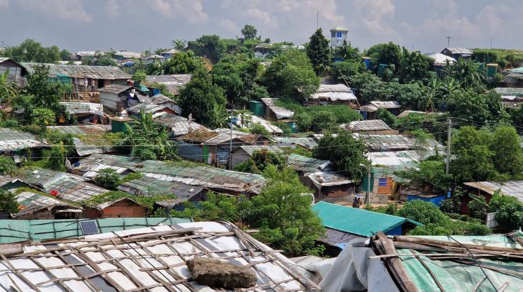 Camp in Bangladesh. Credit: Space Research Centre PAS
Scientists from Poland and Norway have used satellite data to analyse large refugee camps in Tanzania, Bangladesh, Iraq, South Sudan and Kenya.
According to the researchers, satellite observations combined with field work allow them to understand the dynamics of such places and implement appropriate aid programs.
The ARICA project that combines earth and environmental sciences with social sciences is coming to an end. Its purpose is to use the capabilities of satellites to monitor areas where camps for refugees and internally displaced persons are located. Polish researchers from the Space Research Centre PAS, The University of Warsaw and UNEP GRID-Warsaw participate in the project.
'We focus on the analysis of interactions between the camp inhabitants and the environment. We combine the practice of local authorities with field research and satellite observations to give the broadest possible overview of the problems affecting refugee camps. The more so that more such camps may emerge due to climate change. We need to find out how best to help the people living there and protect the natural environment from degradation,’ says project leader Dr. Małgorzata Jenerowicz-Sanikowska from the Earth Observation Department of the Space Research Centre of the Polish Academy of Sciences.
The researchers focused on five camps, one each from Tanzania, Bangladesh, Iraq, South Sudan and Kenya.
TANZANIA
The first of the studied facilities was the Mtendeli war refugee camp in Tanzania (closed at the end of 2021). In 2016-2021, 50,000 refugees lived in an area of 15 square kilometres. The camp was located only five kilometres from a wildlife reserve. According to the ARICA project representatives, locating the camp in such a place, together with problems with supplies, led to environmental degradation.
'The camp was inhabited by people from one of the poorest countries in the world, Burundi. Due to supply shortages, in order to have fuel for cooking, refugees killed trees, so that they could legally cut them down for firewood after the trees withered,’ says Dr. Jenerowicz- Sanikowska.
Thanks to satellite data, it was possible to observe the expansion of the camp, the emergence of agricultural crops in the area, grass burning and deforestation.
'Since 2022, intensive reconstruction of the environment in the camp area has been underway. Species of fast-growing plants - eucalyptus and banana trees - are being planted. Satellite images show that the environment is regenerating,’ says Jenerowicz- Sanikowska.
BANGLADESH
The next camp was the Kutupalong refugee camp in Bangladesh. Due to the intensive influx of war refugees from Myanmar in 2017 (the Rohingya crisis), the camp was transformed into a settlement called Kutupalong - Balukhali. In 2018, it became the world's largest refugee camp, home to around 800,000 people. more or less as many as the population of Kraków according to the Space Research Centre PAS release.
'A team of ARICA scientists arrived at the camp in October 2022. Thanks to cooperation with scientists from the Jagannath University, we were able to freely move around the area and interview the inhabitants. We noticed a significant adaptation of the camp inhabitants and growing ties with the local community,’ Dr. Jenerowicz- Sanikowska says.
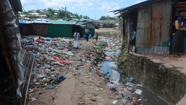
The inhabitants of the camp have access to gas in cylinders, thanks to which there is no massive cutting down of trees. The greatest deforestation occurred in the early stages of the camp due to the clearing of the forest to prepare the space area and to obtain firewood and building materials. 'A huge problem is water and soil pollution. There is no waste management. Garbage is thrown straight into the sewers. And although it flows outside the camp, it stops in the nearby fields. This has led to a huge degradation of crops.
'Another threat is the closure of the natural ecological corridor for elephants. It was located exactly where the camp is now, exposing the inhabitants to attacks by these large animals. There is an obvious conflict between man and the natural environment,’ Jenerowicz- Sanikowska adds.
IRAQ
The third analysed facility was the internally displaced persons camp Khanke in Iraq.
This camp is inhabited by Yazidis living on the Iraq and Iran border. The Yazidis are persecuted by the Sunnis of the Islamic State. The camp is twice as large as the statistics say, because it is divided into an official and an unofficial part. The unofficial camp is inhabited by people who did not qualify for the official camp. There is no state or international aid program reaching this place.
'We have not noticed a big change on the camp-environment line. There are pastures and farmland around the camp, and the camp itself lies within the boundaries of the city of Khanke. The people living there strive for full independence. Before the persecution began, they were a wealthy minority. Suddenly they had to abandon their homes. They lost all their property, often leaving only with what they were wearing. The 'Great Job' project has been implemented by the Eagle Watch Foundation since 2017. Its assumption is to help families become independent by creating the necessary jobs for communities,’ says Dr Jenerowicz-Sanikowska.
SOUTH SUDAN
The fourth camp was the Kaya refugee camp in South Sudan, opened in 2013. The total area prepared for settlement is 712 ha, and it was intended to accommodate 70,000 people. In 2020, the camp was inhabited by 24,000 people who have fled violence and civil unrest in the neighbouring Blue Nile region (Sudan). The camp is located in a region prone to flooding. Because of floods, there is a high risk of food shortages. There is no access to gas, and the inhabitants of the camp have to obtain fuel on their own.
Demand for building materials, fuel and agricultural products led to rapid deforestation in and around the camp. Intensive burnout is observed in the study area every year. Many refugees have taken measures to enable them to survive. An example is the production and sale of efficient kitchen stoves and agricultural activity, the cultivation of guava.
KENYA
The last place described in the project was a camp for people fleeing war and famine in Somalia - Ifo2 in Kenya, officially closed in 2019 as a result of reducing the number of refugees under the voluntary return program.
More than 52,000 refugees lived in an area of 10 square kilometres. The demand for firewood and building materials from both the host community and the refugee camp contributed to the overall trend of environmental degradation (Dadaab camp complex).
In addition, this camp is located in a location prone to flooding, which, together with burns, is observed from the satellite ceiling.
After the closure of the camp, nature began to recover quickly. 'Due to the prevailing temperatures, the growing season lasts all year round. We saw in satellite images that a few rainy days were enough for the vegetation to virtually explode,’ says Dr Jenerowicz-Sanikowska.
At the turn of 2021-2022, the drought and famine crisis ravaging the Horn of Africa and northern Kenya resulted in a renewed influx of refugees into the country. By decision of the government, the Ifo2 camp was reopened.
The obtained results and conclusions from the project, which has been ongoing since September 2020, will be published on an open internet platform, where they will be used to better understand the dynamics of refugee and internally displaced persons camps and their environmental impact.
The goal is to help better organize aid, create guidelines for the location of the camps and their needs, and expand aid and environmental programs.
'While analysing the data collected for selected locations, we noticed, among other things, that simply leaving the area after the closure of the camp without human intervention causes spontaneous reclamation of the environment,’ Jenerowicz-Sanikowska says.
The project ARICA (A multi-directional analysis of refugee/IDP camp areas based on HR/VHR satellite data) was managed by the Space Research Centre of the Polish Academy of Sciences. It also involved scientists from the Migration Research Centre of the University of Warsaw, the UNEP/GRID-Warsaw Center and the Norwegian research institute NORCE-Norwegian Research Centre AS.
Find out more about the project - on THIS page.
PAP - Science in Poland
lt/ agt/ kap/
tr. RL
Przed dodaniem komentarza prosimy o zapoznanie z Regulaminem forum serwisu Nauka w Polsce.