Laser and microwaves integrated on navigation satellites
 Press materials
Two independent satellite technologies (microwave - GNSS and laser - SLR) have been successfully integrated for the first time. Taking place on the Galileo and GLONASS navigation satellites, the integration means the Earth reference systems can be achieved in space and give more precise observations of our planet.
The satellite technologies were integrated by scientists from the Institute of Geodesy and Geoinformatics of the Wrocław University of Environmental and Life Sciences and the Technical University of Munich.
The integration of laser and microwave observations makes it possible to more accurately determine the variation of the length of the day, and connect station networks on different continents using vectors in space, on the GNSS satellites.
GLOBAL GEODESY
The study and description of the Earth system consists in identifying the phenomena occurring in it and locating them in time and space. Global geodesy will ensure accurate and stable reference system for observations of, for example, the movement of tectonic plates, changes in the level of ocean waters, precise navigation, as well as the implementation of geodetic work.
Currently, the global spatial reference system is carried out only by means of space and satellite technologies (Global Navigation Satellite Systems, GNSS), laser retroreflector arrays (LRA) for Satellite Laser Ranging (SLR). Alongside the Very Long Baseline Interferometry (VLBI) and Doppler Orbitography and Radiopositioning Integrated by Satellite (DORIS).
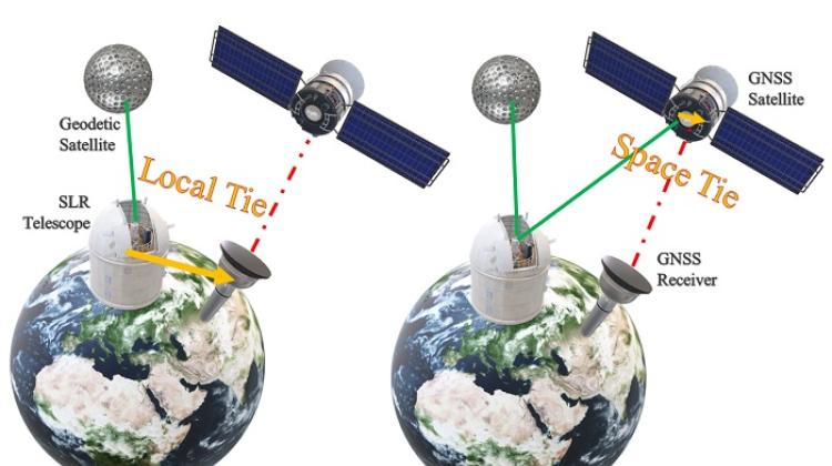
The contribution of individual space technologies is currently considered separately, while their combination is achieved by means of locally measured tie vectors between receivers of individual systems in observatories on Earth. These vectors are obtained as a result of calculations performed on the basis of ground-based geodetic observations, which are collected using geodetic instruments, such as precise levels and tachymeters. However, the calculation of local tie vectors do not take place operationally, but once every few years, and observations are carried out between often ambiguously identifiable receiving centres of instruments of individual systems, as the point where microwaves are collected can not be accurately identified. In addition, local vectors contain information between the sensors of individual techniques located in one observatory.
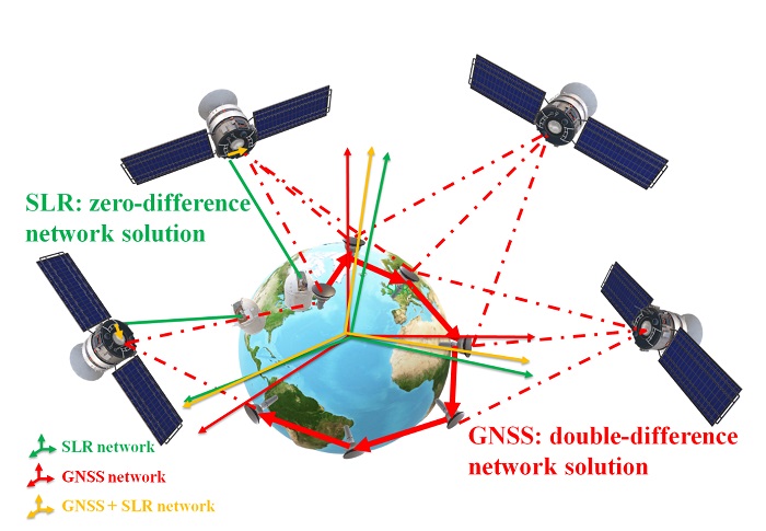
Scientists from the Wrocław University of Environmental and Life Sciences and the Technical University of Munich used microwave observations from GPS, GLONASS and Galileo satellites and laser observations to Galileo and GLONASS satellites. Tests have shown that the best variant is a coherent imposition of minimum conditions: zero rotation and translation on both station networks. The researchers also examined the possibility of transferring the network orientation from the GNSS network through the satellites onto the SLR network and the accuracy of the linkage on GNSS satellites. Based on vectors linking both techniques on GNSS satellites, local vectors between selected SLR and GNSS stations were reconstructed. They ensured long-term combination stability and compliance with local measurements.
SATELLITE NAVIGATION TECHNIQUES
Modern navigation satellites of the global navigation satellites systems such as the European Galileo, Russian GLONASS, and Chinese BeiDou are equipped with laser retroreflector arrays for SLR. They enable terrestrial SLR stations to track satellites. The linkage of the two space techniques (GNSS and SLR) is achieved by using a vector in space between the GNSS antenna phase centre and the centroid of the SLR retroreflector.
So far, the SLR-to-GNSS observations were mainly used as an independent tool for the validation of precise GNSS satellite orbit products. The potential of laser observations to GNSS satellites was neglected when creating the global terrestrial reference frames due to the complexity of the data processing of two completely different space geodetic techniques: microwave and laser observations.
PAP - Science in Poland
kol/ zan/ kap/
tr. RL
Przed dodaniem komentarza prosimy o zapoznanie z Regulaminem forum serwisu Nauka w Polsce.